Climate Data
December 2021 Weather Summary for Belize
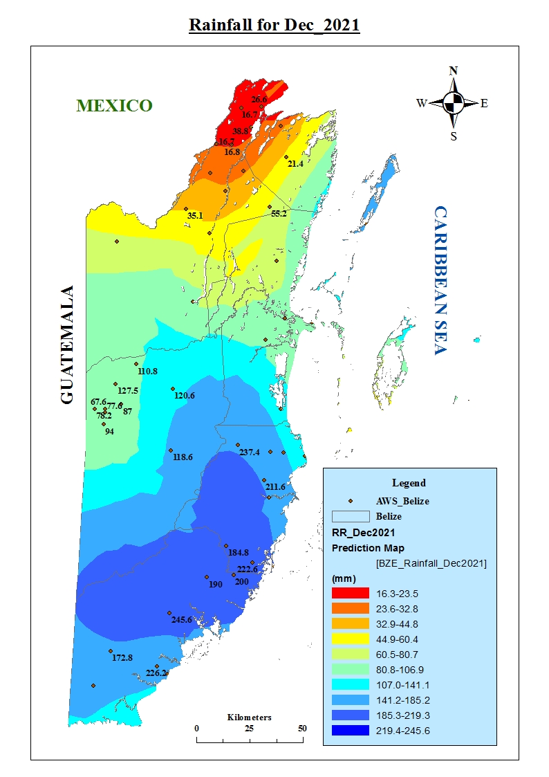
December begins the transition period from the wet season into the cool period of the dry season. Conditions over the area are typically cooler due to the progression of frontal systems from the southeast United States. It is also one of the months where the passage of cold fronts peak in Belize. On average, a total of eight cold fronts, two stationary fronts, eight upper-level troughs and four surface troughs would influence weather conditions and rainfall in December. Overall, rainfall was below normal over most areas, except for parts of south-eastern Belize.
The first week saw relatively dry conditions over most areas in both the low and upper levels on most days due to ridging over the area, except for the 4th where a surface trough was the main feature. Low levels winds were north to northeast up the 5th then became east to southeast on the 5th and 7th. Little upper-level support persisted this week due to a high-pressure ridge over the area with a neutral to weakly convergent pattern and a south-westerly wind component. As a result, mainly fair weather prevailed with isolated showers, except for December 3, 4 and 7 where a few showers affected mostly central and southern locations due to the low-level trough.
Moisture levels began to increase in week 2 in the low levels, but the upper levels continued relatively dry except for December 14th when a surface trough was over the northwest Caribbean. A moderate east to north-easterly airflow prevailed due to a broad low over the area from the monsoon trough over Central America. Ridging continued to dominate at the upper level and a west to south-westerly flow prevailed with a weakly divergent pattern through to the 10th. The upper-level flow became east to north-easterly for the remainder of the period as an upper level TUTT moved east of the country on the 11th and a neutral to weakly convergent pattern prevailed. Showers were isolated to start the week and gradually increased to a few affecting most areas, especially over central and southern locations. Activity increased further on December 14th with a surface trough over the Yucatan Peninsula influencing the weather leading to some showers and isolated thunderstorms over central southern and offshore areas.
Conditions continued relatively moist in week 3 with higher amounts of moisture over southern locations, except for December 18. An east to north-easterly airflow prevailed on the 15th to 17th, then became east to south-easterly on the 18th and 19th as a ridge dominated the area. At the upper levels, a weakly divergent pattern prevailed from the 15th to 17 then became neutral to weakly convergent with a south-westerly upper-level flow due to an upper-level ridge, except for the 18th and 19th where the flow was north and north-westerly. The moist conditions and somewhat unstable upper levels supporting an increase in showery activity which was further enhanced as the first cold front for the most approached and crossed the country late December 21. Some showers and a few thunderstorms continued from December 14 to the 17, especially over central and southern locations with a few elsewhere from pre-frontal activity. Showers and thunderstorms were isolated and affected mostly central and southern locations to December 20 with a few on the 21st associated with the cold front that affected mostly offshore and southern areas.
Towards the end of the month, drier conditions began to set in with limited moisture in the low levels and very dry at the upper levels as a high-pressure ridge build behind the cold front. A north and north-westerly flow prevailed on the 22nd and 23rd then it veered and became north-easterly through the 26th. A surface trough persisted to December 27th before ridging became the dominant feature over the area. The upper-level pattern was neutral to weakly convergent, and an upper-level trough extended from the Bahamas to eastern Honduras on December 22nd and 23rd, then a ridge prevailed from the 24th to 31st with a south-westerly flow. Cool and cloudy conditions lingered over the area behind the front until December 24th, the isolated showers affected mostly the coast and offshore areas on the 25 to 27. Little to no rainfall was observed to end the month.
Click on the link below to view the rainfall data for December 2021:
Rainfall December 2021
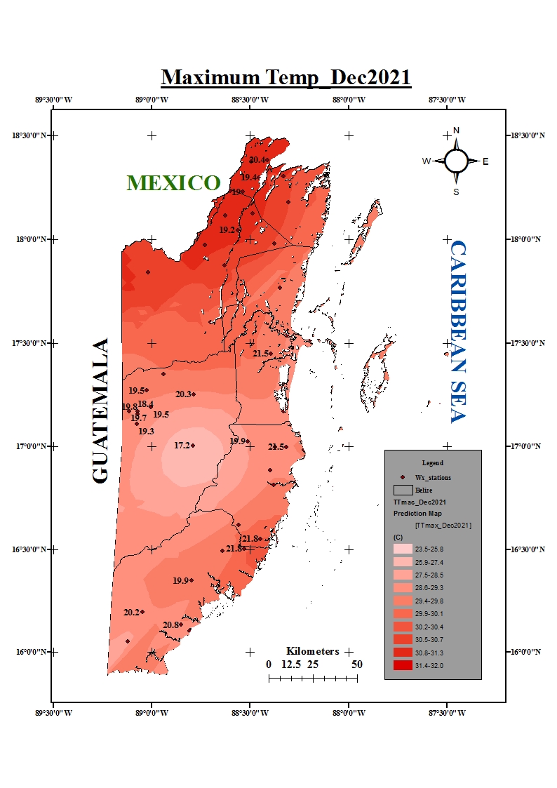
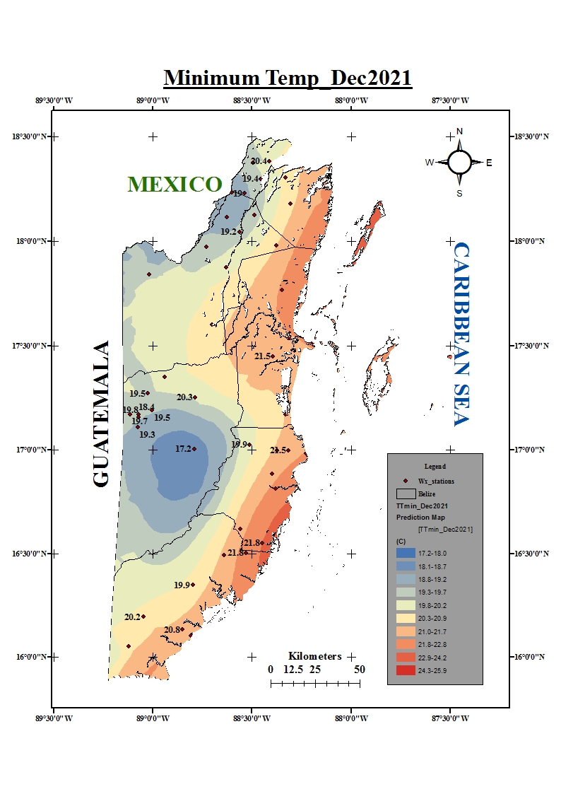
Click on the link below to view the temperature data for December 2021:
Maximum temperature December 2021
Minimum temperature December 2021
Monthly Weather Summaries(2018/19)


